Drones are now the fastest-growing segment of US aviation, with the commercial fleet projected to pass one million aircraft, and the security problem has grown with it. The FAA recorded 411 illegal drone incursions near US airports in the first quarter of 2025, a 25.6 percent increase over the same period a year earlier, and an Associated Press analysis found that nearly two-thirds of reported near midair collisions at the 30 busiest US airports involved drones. The question for anyone responsible for a site is no longer whether to watch the airspace, but how the systems that do it actually work.
We believe a drone detection system is best understood as three things working together, not one box on a pole: the sensors that find a drone, the software that fuses what those sensors see into a single picture, and the coverage that keeps watching continuously and catches the drones trying not to be seen. Get all three right and you have airspace awareness you can act on. Get only the first and you have an expensive alarm. This guide walks through each layer in turn and the legal boundary that defines what your coverage is allowed to do.
What is a drone detection system?
A drone detection system is an integrated set of sensors and software that finds, tracks, and identifies unmanned aircraft in a defined airspace. The federal Cybersecurity and Infrastructure Security Agency frames detection around a handful of sensor families in its UAS detection technology guidance, and the practical distinction that matters is between a single device and a true system. A handheld detector is a device. A system combines multiple sensors with software and watches an area continuously and unattended.
That distinction is the whole story of why detection has moved from gadgets to platforms. A single sensor has a single blind spot, so a credible system layers several methods and ties them together. The rest of this guide follows the data through the system: into the sensors, through the software, and out across the coverage area. Our breakdown of anti-drone devices from handheld units to enterprise systems shows how far apart those two ends of the market really are.
The sensors: how a detection system sees a drone
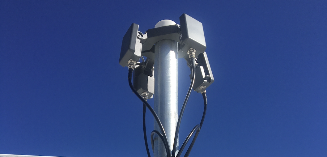
Every detection system starts with sensors, and almost all of them draw from four families. The US Government Accountability Office describes the core set plainly, noting that detection technologies include infrared devices to track heat signatures, radio frequency systems to scan for control signals, and acoustic methods to recognize the unique sounds produced by drone motors, alongside radar. Each one sees the airspace differently.
- Radio frequency (RF) sensors listen for the wireless link between a drone and its pilot. They flag most commercially operated drones at range and often reveal the operator's location, without the drone broadcasting any identification.
- Radar senses anything that moves and reflects energy. It tracks a drone that emits no radio signal at all, including autonomous and home-built aircraft, which makes it essential for non-cooperative threats.
- Electro-optical and infrared (EO/IR) cameras add the visual layer, reading the airframe and the heat of the motors to turn a raw detection into a positive, human-verifiable identification.
- Acoustic sensors recognize the distinctive sound of drone propellers and motors. They work at shorter range but help in cluttered settings where other sensors struggle.
The reason systems combine these is that no single one is sufficient, and the GAO is direct about the limits. It reports that radio frequency and radar systems are the most common detection technologies, precisely because the pair cover each other: RF catches the cooperative, broadcasting drone cheaply, and radar catches the quiet one RF misses. Most of those sensors live across several physical hardware detection layers, and our guide to how RF detection identifies unauthorized drones goes a level deeper on what one of those layers can and cannot reveal.
The software: turning sensor data into one picture
Sensors produce signals, but signals are not awareness. A system that hands an operator four separate alarm screens, one per sensor, has pushed the hardest job, correlation, onto a human under pressure. The software layer is what turns raw detections into a single, trustworthy track, and it is the part of a drone detection system that most buyers underestimate.
Good command-and-control software does three things at once. It fuses overlapping detections from different sensors into one track, so a single drone shows up once rather than as three uncoordinated blips. It filters environmental noise, which matters because the GAO warns that electromagnetic interference such as power lines and LEDs, and small airborne objects such as birds, can decrease detection capabilities or generate false detections. And it classifies what it is seeing, including reading the public broadcast from compliant drones. Under the FAA's Remote ID rule, most drones weighing 0.55 pounds or more must broadcast their identification and location over Bluetooth and Wi-Fi, and the software folds that identity into the same picture as the radar and RF tracks.
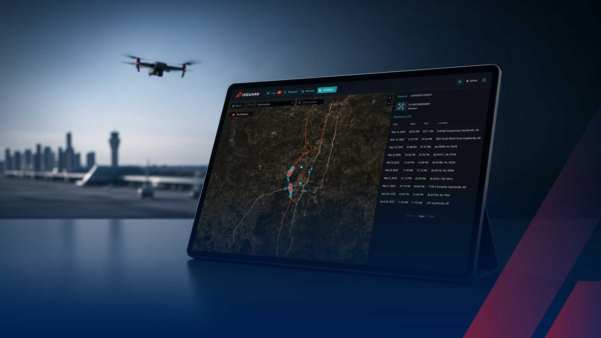
This fusion is the entire point of our AirGuard command-and-control platform, which unifies radar, RF, and Remote ID into one operating picture so the whole is more reliable than any sensor on its own. When you evaluate a system, the right question is not which sensor is best, but how well the software combines them into something an operator can actually trust at three in the morning.
Coverage: continuous watch and the non-cooperative drone
The third layer is coverage, and it has two parts: watching all the time, and watching for the drones that do not want to be found. A handheld detector covers the space around one person while it is switched on. A fixed system covers a defined perimeter continuously and unattended, which is the only posture that matches a threat that can arrive at any hour.
The harder half of coverage is the non-cooperative drone. The 2026 GAO assessment of aviation transformation is blunt that existing approaches struggle when aircraft are not broadcasting their position electronically, the exact condition a hostile or careless operator creates by simply not complying. A system whose coverage depends on Remote ID or the RF link alone has a hole shaped like every drone flown to avoid detection. Radar is what fills that hole, but only if the system can find small targets, and the GAO cautions that some of these technologies have a limited ability to detect and track small UAS under 55 pounds, which is the weight class most likely to appear over a stadium or a substation. Real coverage is measured by the drones a system catches when nothing is cooperating.
The legal boundary: what your coverage is allowed to do
Coverage also has a legal ceiling that the spec sheet will not mention, and it shapes what kind of system you can lawfully run. There is a sharp line between detecting a drone and doing something to stop it. Congress has authorized only the Departments of Defense, Energy, Justice, and Homeland Security to actively mitigate drones, so jammers, spoofers, and kinetic tools are off the table for nearly every private operator. An interagency advisory from the FAA, DOJ, DHS, and FCC lays out how federal law applies to detection and mitigation technology, and it is the document to read before buying anything.
Detection is broadly more permissible, but it is not a free pass. The same advisory cautions that some detection methods, especially those that intercept the radio communications between a drone and its operator, can implicate federal criminal surveillance statutes. That is why CISA recommends operators consult legal counsel before adopting UAS detection systems. For nearly every site, the right design is a system that detects, identifies, and documents, with response handed off to authorities, and the legal review done before deployment rather than after.
Putting the three layers together
A drone detection system works when its three layers reinforce each other: sensors that see the drone by more than one physical signature, software that fuses those signals into a single track and strips out the birds, and coverage that runs continuously and still finds the aircraft broadcasting nothing. Drop any layer and the system fails in a predictable way. Skimp on sensors and you get blind spots. Skimp on software and you get alarm fatigue. Skimp on coverage and the quiet drone flies straight through.
We believe the organizations that handle drones well stop asking for a detector and start asking how a system turns sensors, software, and coverage into a decision. With the drone fleet climbing past a million aircraft and the legal lines clearly drawn, the technology to build that awareness exists today, and the only real question is how well the layers are put together.
Interested in seeing how a layered drone detection system would cover your airspace? Contact our team today to schedule a demo.
Frequently asked questions about drone detection systems
What is a drone detection system?
A drone detection system is an integrated set of sensors and software that finds, tracks, and identifies unmanned aircraft in a defined airspace. The sensor layer combines several technologies, typically radio frequency (RF) sensors, radar, electro-optical and infrared cameras, and sometimes acoustic sensors, because no single sensor catches every drone. A command-and-control software layer fuses those overlapping detections into one track an operator can act on. The difference between a system and a single device is that a system provides continuous, unattended coverage and combines methods so it can also find drones that broadcast no identification.
How does a drone detection system work?
It works in three stages. First, sensors detect a drone by different physical signatures: RF sensors listen for the radio link between a drone and its controller, radar senses moving objects that reflect energy, and cameras confirm the target visually. Second, command-and-control software fuses those separate detections into a single track, filters out false alarms such as birds, and classifies the object. Third, the system delivers continuous coverage of a defined area and presents one operating picture so security teams can verify the threat and hand off to authorities. The layering matters because each sensor covers another sensor's blind spot.
What sensors does a drone detection system use?
Most systems are built from four sensor families. Radio frequency (RF) sensors detect the wireless link between a drone and its pilot and often reveal the operator's location. Radar detects any moving object that reflects energy, including drones flying with no radio signal at all. Electro-optical and infrared cameras provide visual and heat-based identification. Acoustic sensors recognize the sound signature of drone motors at shorter range. According to the US Government Accountability Office, radio frequency and radar systems are the most common detection technologies, and serious systems combine several families rather than relying on one.
Can a drone detection system detect drones that are not broadcasting Remote ID?
Yes, but only if the system includes the right sensors. A system that relies on reading Remote ID or RF signals alone will miss a drone flying a pre-programmed route with its radio link cut, or one built to stay quiet. Radar is the layer that closes that gap, because it detects an aircraft by reflected energy whether or not the drone is transmitting anything. This is the central reason professional detection is sold as a multi-sensor system: the drones most likely to matter are the ones deliberately operated to avoid being seen.