Critical Infrastructure Protection
Critical Infrastructure Drone Detection
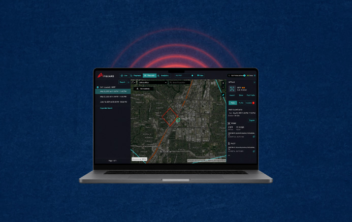
Protect power plants, substations, and energy sites from unauthorized drones. AirGuard detects dark drones, locates pilots in real time, and keeps you compliant — all from one open-architecture platform.
The Threat Landscape
How Drones Threaten Critical Infrastructure
Energy companies increasingly use drones to inspect anomalies and improve safety. What's often overlooked is the unauthorized drones that breach your airspace and pose risks such as espionage, cyber threats, sabotage, and regulatory non-compliance — making proactive drone detection essential for safeguarding power plants, water facilities, communication hubs, and other essential sites.
Unauthorized Surveillance & Espionage
Drones equipped with cameras can gather sensitive data on facility layouts, operational workflows, and security measures, posing a significant risk to national security and corporate confidentiality.
Learn MoreCyber & Data Security Risks
Advanced UAVs can intercept wireless communications, tamper with industrial IoT networks, or even launch cyber-attacks, putting operational integrity and data security at risk.
Learn MorePhysical Sabotage & Interference
Drones can transport malicious payloads, disrupt operations, or damage sensitive equipment — a growing concern for power grids, chemical plants, and large-scale manufacturing facilities.
Learn MoreRegulatory & Compliance Risks
Many industries must adhere to strict federal and industry-specific airspace security regulations. Failure to detect and mitigate drone threats can lead to severe penalties and operational shutdowns.
Learn MoreHow AirGuard Works
A Layered Defense That Sees Every Drone
No single sensor can guarantee total coverage. AirGuard fuses multiple detection layers into one real-time airspace picture — including "dark drones" that broadcast no signal.
Remote ID & Geolocation
Detects the vast majority of consumer drones, including DJI and FAA-mandated Remote ID models, with precise drone and pilot GPS location.
RF & Directional RF
Identifies non-compliant and DIY drones by their unique frequency signatures, pinpointing approach vectors.
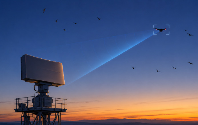
Radar with AI Classification
Catches dark drones that fly without RF signals, distinguishing them from birds, aircraft, and clutter.
24/7 Human Verification
An expert monitoring team verifies every alert, so your team responds only to credible, confirmed threats.
Why Airsight
Why Choose Airsight for Critical Infrastructure Security
A layered, open-architecture approach that secures your airspace and works alongside the systems you already run.
Advanced Detection & Tracking
A layered approach ensures early detection, classification, and response across Remote ID, RF, radar, and visual sensors.
Proactive 24/7 Monitoring
Automated detection with real-time alerts, verified by a live expert team that eliminates false alarms.
Full Regulatory Compliance
Helps facilities meet FAA, DHS, and industry security mandates with documented, evidence-grade detection.
Seamless Security Integration
Works alongside CCTV, perimeter security, access control, physical security teams, and compliance reporting.
Scalable & Adaptable
Deployable across energy, water, telecom, and industrial sectors, and sized to each facility's exposure.
Open-Architecture Platform
Integrate best-in-class sensors without single-vendor lock-in, unified into one AirGuard interface.
How AirGuard Supports Drone Threat & Risk Assessment
Effective airspace security starts with understanding your baseline. Before recommending a configuration, Airsight conducts a site survey and drone threat assessment of your facility — mapping approach vectors, identifying signal-interference challenges from large structures and machinery, and establishing the normal pattern of drone traffic around your perimeter.
This drone risk assessment lets security teams distinguish routine inspection flights from genuine threats and right-size their detection layers to the facility's actual exposure.
Learn how we tailor detection layers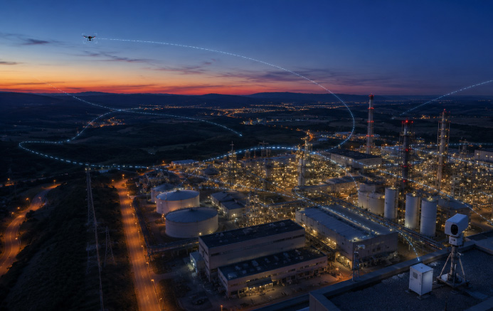
Extending Perimeter Security Into the Airspace
Traditional fences, cameras, and access control secure the ground — leaving the airspace above as a blind spot. AirGuard adds the third dimension to your drone perimeter security, alerting teams to drones crossing the boundary long before a payload could be dropped or surveillance completed.
The result is a single, real-time picture of every drone approaching your site, including the pilot's location, so your team can move from reactive to proactive.
Learn how drone detection worksThe Record
Drone Incidents at U.S. Critical Infrastructure
Drones are no longer a hypothetical threat to America's power grid, nuclear facilities, and energy sites. Federal investigations, foiled plots, and grid-security exercises all point to the same conclusion: critical infrastructure operators need eyes on their airspace.
Drone incursions at 24 U.S. nuclear sites
Documents obtained under the Freedom of Information Act revealed 57 drone incursions across 24 separate U.S. nuclear sites between 2015 and 2019 — underscoring how routinely sensitive facilities are overflown, often without any means to identify the operator.
Source: Forbes FOIA records via GNETFirst drone modified to attack U.S. energy infrastructure
A joint DHS, FBI, and National Counterterrorism Center bulletin assessed that a DJI Mavic 2 recovered near a Pennsylvania electrical substation had been modified to create a short circuit and damage transformers — the first known case targeting U.S. energy infrastructure.
Source: The War Zone / federal intelligence bulletinFBI foils a drone-bomb plot on a Nashville substation
In November 2024, federal agents arrested a 24-year-old who allegedly planned to destroy an electrical substation near Nashville, Tennessee using a drone armed with explosives — one of the first known domestic extremist plots to target critical infrastructure with a UAS.
Source: CBS NewsGrid-security exercise exposed a drone vulnerability
NERC's GridEx exercise, run by the E-ISAC in November 2025, simulated a coordinated assault on the power grid that included drone attacks. The exercise highlighted that utilities can often engage a drone only after it has landed — frequently too late to prevent harm.
Source: Utility DiveQuestions, Answered
Critical Infrastructure Drone Detection: FAQ
Common questions from security teams at power plants, substations, and energy sites about detecting and responding to unauthorized drones.
Yes. AirGuard is purpose-built to monitor the airspace over power plants, substations, nuclear stations, and other critical sites. It fuses Remote ID, RF and Directional RF detection, radar, acoustic sensors, and PTZ camera verification into one platform, giving security teams a real-time view of each drone's make, model, speed, altitude, and GPS location, along with the operator's live position. This closes the airspace blind spot that fences, cameras, and access control alone cannot cover.
Traditional perimeter security — fences, cameras, access control — stops at ground level, leaving the airspace above a site undefended. AirGuard extends perimeter security into the sky, detecting drones as they approach the boundary and tracking their flight path and the operator's location well before they reach sensitive areas. Because radar provides continuous coverage with no minimum range, it is especially effective against drones launched from just outside the fence line, giving security teams early warning to respond.
Yes. Effective drone risk assessment starts with knowing what is actually flying over your site. AirGuard logs every detection — drone type, flight path, altitude, and frequency — and analyzes activity trends over time, so security teams can identify recurring patterns, high-traffic zones, and the periods of greatest exposure. This data-driven picture lets critical-infrastructure operators quantify their airspace threat, prioritize vulnerable areas, and build informed security protocols rather than relying on assumptions.
Yes. AirGuard lets your organization "white-list" drones you authorize on your site. The software recognizes those drones and records their activity without triggering alerts, while still flagging unauthorized aircraft. This means utilities and energy operators can keep using drones for inspections, diagnostics, and quality assurance — tracking and recording authorized flights — without losing the ability to detect a genuine intrusion.
For most private operators, no. Federal law prohibits private entities from jamming, shooting down, or otherwise interfering with aircraft, including drones — those mitigation authorities are restricted to specific federal agencies. That is why AirGuard focuses on detection, documentation, and coordination: identifying the drone and pilot, recording the incident as evidence, and giving your team and law enforcement the real-time intelligence to respond lawfully. Several states have also made it a criminal offense to fly drones over critical infrastructure, strengthening the case for documented detection.
No single sensor can guarantee total coverage, which is why AirGuard uses a layered defense designed to detect the overwhelming majority of drones. Remote ID and geolocation catch the vast majority of consumer drones, including DJI and FAA-mandated Remote ID models; Directional RF identifies non-compliant drones by their frequency signatures; and radar with AI classification catches "dark drones" that fly without any RF signal, differentiating a genuine drone from birds, aircraft, and clutter using integrated hardware from radar partners such as Echodyne, Fortem, Magos, and O.W.L. A 24/7 live monitoring team verifies every alert, so infrastructure teams respond only to credible, confirmed threats rather than chasing false alarms.
Yes. Because AirGuard is built on an open architecture, it integrates with the systems you already run rather than replacing them. It provides the GPS location and altitude of detected drones to PTZ cameras so they can track and identify payload and threat potential, and it connects with Video Management Systems, alarm and incident management systems, License Plate Recognition, cloud analytics, and Real-Time Crime Center and Emergency Operations Center platforms. This unified view helps security teams and law enforcement make informed decisions from a single interface.
Airsight acts as a vendor-neutral validator rather than a single-hardware reseller. The company purchases and stress-tests detection equipment from global vendors at its Dallas headquarters and dedicated test sites, integrating only the technology that proves reliable into the AirGuard platform. This open-architecture approach eliminates single-vendor lock-in, lets each facility deploy best-in-class sensors suited to its specific environment, and is backed by a 24/7 expert monitoring team that verifies alerts so operators respond only to confirmed threats.
Secure Your Airspace Before the Next Incursion
See how AirGuard gives your security team a real-time picture of every drone over your facility. Book a demo or request a site survey today.