In April 2026, the Boston Globe reported that Boston Police received $10.6 million in federal grants to stock up on counter-drone gear, Massachusetts State Police received $6.7 million, and the town of Foxborough alone took in $3.5 million. They are not outliers. Eleven states are splitting $625 million in FEMA funding for FIFA World Cup 2026 counter-drone security, and a separate $500 million FEMA C-UAS Grant Program is available to all 56 states and territories starting in FY2027. Counter-drone technology is no longer a military niche. It is a local law enforcement procurement category with a billion-dollar federal funding pipeline behind it.
We have been building counter-drone detection technology for organizations that needed it before the funding arrived. What we are seeing now is an inflection point: thousands of agencies are evaluating counter-drone technology for the first time, often without a clear understanding of what the technology stack includes, what each layer does, and which layers they are legally authorized to deploy. This guide maps the full counter-drone technology landscape in 2026, from detection through mitigation, and draws a clear line between what any organization can deploy today and what requires federal certification under the SAFER SKIES Act.
The Four Phases of Counter-Drone Technology
The counter-drone workflow follows a framework the industry calls DTIM: Detect, Track, Identify, Mitigate. Each phase uses different technology, has different legal requirements, and serves a different operational purpose. Understanding where one phase ends and another begins is critical, because the legal line between detection and mitigation is the most important boundary in counter-drone operations today.
We covered the full DTIM workflow in a previous guide. Here, we focus on the technology that powers each phase and the 2026 regulatory landscape that governs its use.
Phase 1: Detection Technology
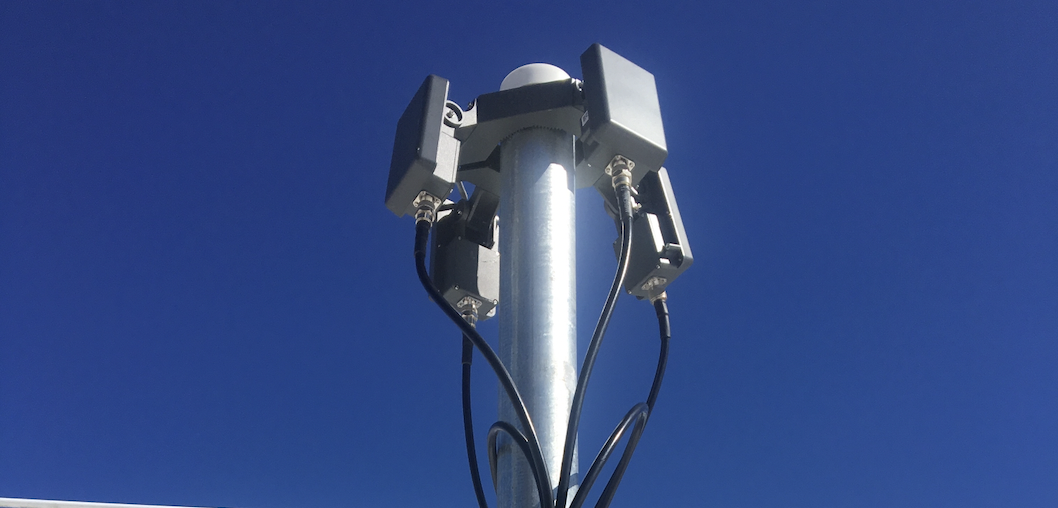
Detection is the moment a sensor registers that a drone is present in the airspace. This is the foundation of every counter-drone deployment and the most universally legal phase of the DTIM chain. No federal certification is required to detect drones. Any organization can deploy detection technology today.
Five sensor types power the detection phase:
-
RF sensors scan for the radio frequency signals between a drone and its controller. They identify the drone's make and model from its RF signature and can often locate the operator. RF is the workhorse of commercial detection because most threat drones are consumer models that broadcast on known frequencies.
-
Radar detects physical objects in the airspace regardless of whether they transmit a signal. It is the only sensor that reliably catches autonomous or modified drones. For a detailed breakdown, read our drone detection radar guide.
-
Remote ID receivers capture the FAA-mandated broadcast identification signals from compliant drones, providing serial numbers and operator GPS coordinates.
-
Cameras (EO/IR) provide visual confirmation of detected targets. Thermal cameras extend coverage into nighttime operations.
-
Acoustic sensors detect propeller noise signatures in quiet environments where other sensor types may be unnecessary or cost-prohibitive.
For a complete comparison of each sensor type's strengths and blind spots, read our guide on how drone detectors work. The critical point: no single sensor covers all threats. The Security Industry Association's evaluation guide warns that systems with high false positive rates are eventually ignored by operators. Multi-sensor deployments that layer RF, radar, and cameras reduce false alarms while closing the detection gaps that each sensor has individually.
Phase 2: Tracking Technology
Tracking is the process of maintaining continuous custody of a detected drone as it moves through the airspace. Detection tells you a drone exists. Tracking tells you where it is going, how fast it is moving, and whether it is approaching your facility or flying past.
Effective tracking requires three capabilities:
-
Overlapping sensor coverage so that when one sensor loses the target (a drone drops below a treeline, enters a radar shadow, or moves outside an RF sector), another sensor picks it up without breaking the track.
-
Data fusion algorithms in the command-and-control platform that merge detections from multiple sensors into a single unified track. Without fusion, the same drone appears as separate icons from each sensor, inflating the apparent threat count and confusing operators.
-
Camera cueing that automatically slews a PTZ camera to the drone's position based on radar or RF coordinates. This delivers visual confirmation without requiring an operator to search the sky manually.
Tracking is where the command-and-control platform becomes the critical differentiator. Individual sensors generate data. The C2 platform fuses that data into a single operating picture. Without it, an operator staring at three separate screens for radar, RF, and cameras cannot maintain situational awareness when multiple drones enter the airspace simultaneously.
Phase 3: Identification Technology
Not every drone in your airspace is a threat. Commercial delivery drones, authorized surveying aircraft, law enforcement UAS, and recreational hobbyists all share low-altitude airspace. Identification is the process of determining what a drone is, who is flying it, and whether it is authorized.
Identification technology includes:
-
RF fingerprinting that matches a drone's signal against a library of known models. If the system identifies a DJI Mini 3 on standard frequencies, that is a different threat profile than an unidentified signal on a non-standard frequency.
-
Remote ID decoding that extracts the drone's serial number, operator position, and flight telemetry from the FAA-mandated broadcast. This is the fastest path from detection to identification for compliant drones.
-
Micro-Doppler classification from radar that distinguishes drones from birds based on propeller rotation signatures.
-
Visual classification through cameras that allows operators to assess payload, size, and behavior. A drone hovering over a correctional facility with a package attached requires a different response than a hobbyist drone passing through.
Identification is where most organizations underinvest. Detection and tracking get the budget because they are tangible hardware purchases. But without reliable classification, every detection triggers the same response, and security teams quickly develop alert fatigue.
Phase 4: Mitigation Technology
Mitigation is the phase that changed in December 2025. Before the SAFER SKIES Act, only federal agencies (DHS, DOJ, DOD) had legal authority to interfere with drones. The SAFER SKIES Act, signed as part of the FY2026 NDAA, extends that authority to certified state, local, tribal, and territorial law enforcement and correctional agencies for the first time.
Mitigation technology falls into three categories:
-
RF jamming and spoofing: Disrupts the communication link between the drone and its controller, forcing the drone to land, return to home, or hover in place. Cyber-takeover systems can seize control of the drone and command it to land at a designated location. These remain the most common mitigation tools for law enforcement. As the FBI outlined at the DRONERESPONDERS conference in March 2026, mitigation technologies require extensive in-person training and certification due to the higher operational risks. For a deep dive on how drone jammers work and who can legally use them, read our full guide.
-
Kinetic interception: Physical capture or destruction of the drone. Fortem Technologies' DroneHunter uses a net-carrying drone to capture targets in flight, claiming 4,700 safe takedowns. Net-based and projectile-based systems are typically reserved for high-threat scenarios where electronic countermeasures are insufficient or where the drone is not using a jammable signal.
-
Drone-as-First-Responder (DFR): A non-kinetic response that deploys an authorized drone to visually confirm the threat, track the target, locate the pilot, and document the incident for law enforcement. For agencies without mitigation authority, DFR is the most effective response option available today.
The legal boundary: Detection, tracking, and identification are legal for any organization. Mitigation requires SAFER SKIES Act certification. Only individual officers who complete DOJ-approved training at the FBI National Counter-UAS Training Center in Huntsville, Alabama may exercise counter-UAS mitigation authority. One trained officer does not grant authority to an entire agency. Certification is individual, role-specific, and federally overseen. Agencies may only use counter-UAS systems that appear on a jointly maintained federal list of authorized technologies, developed by DOJ, DHS, DOD, DOT, the FCC, and NTIA.
Federal Funding for Counter-Drone Technology in 2026
The funding landscape has never been larger. Three federal channels are now active:
-
FEMA C-UAS Grant Program ($500M): $250 million awarded to 11 FIFA World Cup host states in FY2026. Another $250 million opens to all 56 states and territories in FY2027. Covers detection, tracking, identification, and monitoring equipment at 100% federal funding with no local match required. FEMA called this the fastest non-disaster grant program in its history, with awards issued just 25 days after the application deadline.
-
FIFA World Cup Grant Program ($625M): A separate FEMA-managed program specifically for counter-drone equipment and personnel at World Cup venues across 11 host states.
-
JIATF-401 Counter-UAS Marketplace: For military and federal buyers, the Pentagon's online procurement platform lists more than 1,600 counter-drone items with expedited purchasing.
The practical implication: for organizations in grant-eligible categories (state and local law enforcement, correctional facilities, agencies supporting NSSEs or SEAR 1/2 events), the budget constraint on counter-drone technology may be lower than expected. The constraint is time. Equipment lead times, FBI training backlogs, and implementing regulations due by June 2026 all create urgency for agencies that have not yet begun the procurement process.
What Most First-Time Counter-Drone Buyers Get Wrong
After working with organizations across prisons, airports, stadiums, and critical infrastructure sites, we see three consistent mistakes from agencies entering the counter-drone market for the first time:
-
Starting with mitigation before mastering detection. Mitigation sounds decisive. Detection sounds passive. But mitigation without reliable detection, tracking, and identification is blind force. You cannot jam a drone you have not detected. You cannot prosecute an operator you have not identified. Detection is the foundation, and for most agencies, it is the first procurement that should happen, especially since detection requires no federal certification.
-
Buying sensors without a command-and-control platform. Individual sensors generate individual data streams. Without a C2 platform that fuses those streams into a single operating picture, operators are juggling multiple screens, multiple alert systems, and multiple interfaces. The result is slower response times, duplicate tracks, and alert fatigue. Our equipment buyer's guide covers this integration requirement in detail.
-
Underestimating the site survey. Detection range on a vendor's data sheet assumes ideal conditions. Your site has buildings, terrain, electromagnetic interference, and bird populations that will degrade performance. Any credible vendor will conduct a site survey before recommending equipment. If they skip this step, that is a red flag.
What Comes Next: The Counter-Drone Market in 2027 and Beyond
The counter-drone technology landscape is moving on two tracks simultaneously. The regulatory track is accelerating: implementing regulations under the SAFER SKIES Act are due by June 2026, the FBI's National Counter-UAS Training Center is scaling enrollment, and FEMA's FY2027 grant round will extend funding to all 56 states and territories. The technology track is advancing in parallel: multi-sensor fusion is becoming a baseline requirement, AI-powered classification is reducing false alarm rates, and detection platforms are integrating directly with response systems.
For organizations evaluating counter-drone technology today, the most important decision is not which specific product to buy. It is which layer to invest in first. For the vast majority of new entrants, the answer is detection. It is universally legal. It is the prerequisite for every subsequent phase. It generates the data that supports FEMA grant renewals, law enforcement investigations, and compliance reporting. And it is the layer that determines whether mitigation, when authorized, has a target to act on.
For a framework on building your detection layer by protection level and facility type, and for the four-question vendor evaluation framework we recommend to every new buyer, start there. Then come talk to us.
Ready to evaluate counter-drone technology for your agency or facility? Book a walkthrough with our team.
Related reading: