Drones are mobile by design. They cross fences, fly beyond perimeters, and rarely stay in one place. For security teams monitoring sensitive or high-value sites, that mobility poses a challenge—especially when incidents at separate locations may be connected.
With the latest update to our drone detection software, AirGuard, users can now take a broader view of drone activity. The new Expanded Geo-Fence Drone Search feature gives authorized users the ability to query drone flight records across the entire AirGuard detection network—not just within their own monitored zones.
This enhancement provides a powerful new layer of visibility for teams tasked with understanding how drone threats develop, move, and persist over time.
What Expanded Drone Search Enables
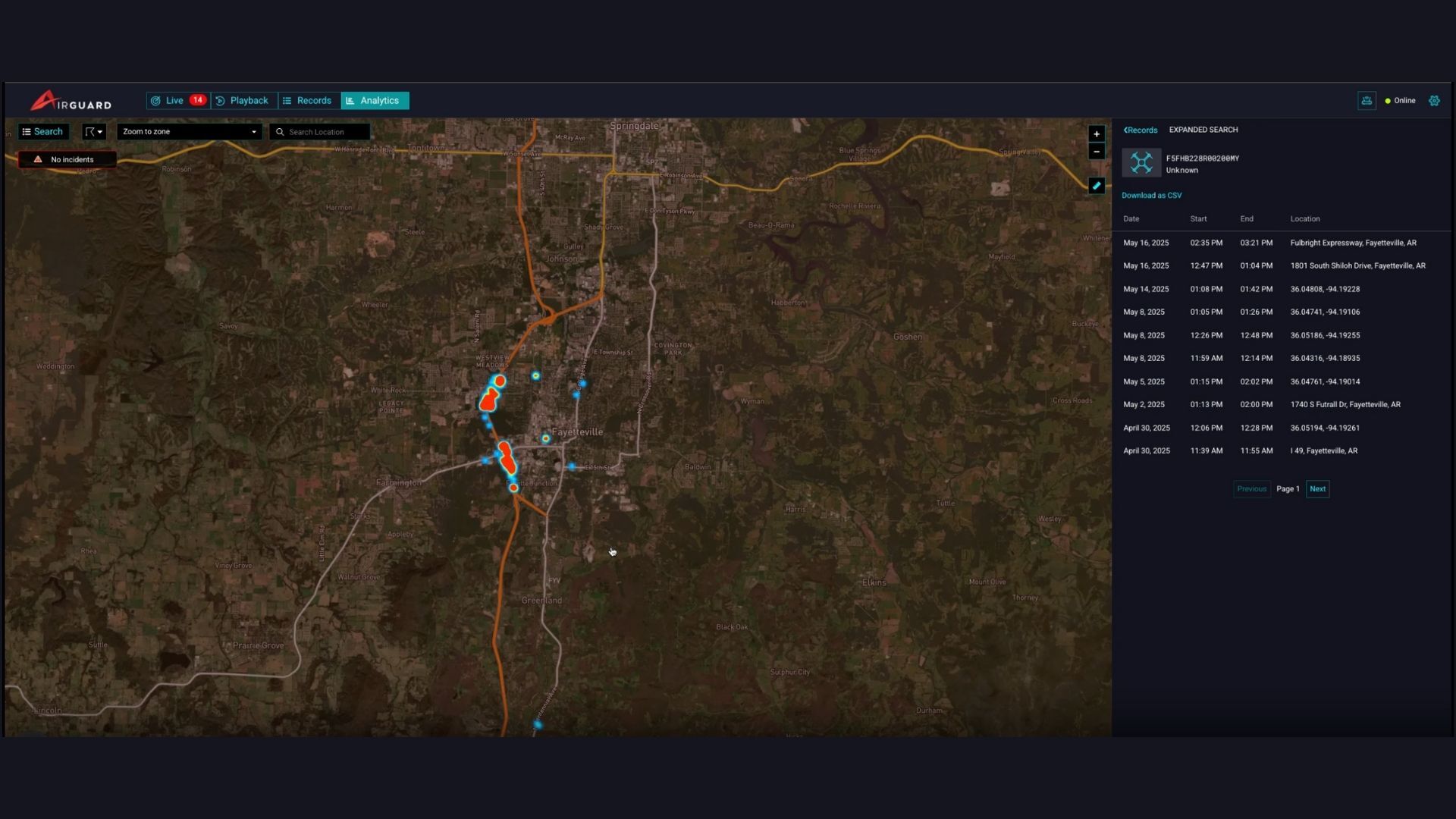
The Expanded Search feature allows AirGuard admin users to search for a specific Drone ID and retrieve flight data detected outside their organization’s assigned geo-fence. The results are displayed both in a tabular format and on a heatmap, making it easier to visualize where and when a drone has been observed across the network.
Combined with filtering tools and exportable data, this feature supports faster investigations, better intelligence-sharing, and a more complete understanding of drone activity over time and space.
Let’s say there’s a regional energy provider that monitors several substations across two states. One day, a drone is detected hovering near transmission lines at Site A. The team logs the flight and monitors for follow-up activity.

Two weeks later, another drone detection is flagged—this time at Site B, several hundred miles away. The flight behavior is similar. Using AirGuard’s Expanded Drone Search, the team searches the Drone ID from the first incident and immediately sees that the same drone was detected at both locations, along with one previous detection at a separate facility weeks earlier.
.png?width=319&height=706&name=image%20(12).png)
Instead of treating each alert as a separate event, the team now has clear evidence of a recurring pattern involving the same device. That context changes the response—from site-level monitoring to a coordinated investigation across all affected locations.
Why Broader Visibility Matters
Drone threats are rarely static. What begins as a single flyover can escalate to repeated surveillance, contraband drops, or infrastructure probing. The ability to search beyond the bounds of a single site helps security professionals:
- Detect recurring drone activity across locations
- Identify potential coordination between incidents
- Support evidence collection with broader flight histories
- Respond proactively, not reactively
Expanded Search doesn't just show where a drone has been—it helps uncover how, when, and why it's being used.
Designed for Investigative Efficiency
This feature is built for teams who need fast answers and clear insights. Whether it’s during a live investigation or a post-incident review, Expanded Search brings together data that would otherwise remain siloed.
From enterprise security teams to infrastructure operators and law enforcement partners, this capability is designed to scale across organizations and geographies—turning drone sightings into strategic intelligence.