Lorem Ipsum
Lorem Ipsum is simply dummy text of the printing and typesetting industry.

The use of drones has increased significantly in the past few years, and is expected to grow at an even faster rate in the upcoming years.
The small model hobbyist fleet is expected to more than triple in size. By 2021, the FAA predicts, 3.55 million drones will be registered. The high end of the of the predictions had it at 4.47 million. The low end was still nearly tripling the current 1.1 million units, with 2.75 million in the skies.

According to the FAA, falling prices, improved technology, easier use and the growth of drones used for sport will drive the growth.
They expect even more growth for the commercial, non-hobbyist fleet. By 2021, the numbers will reach 442,000. That’s more than 10 times the current number (42,000). The average annual growth rate will be more than 58 percent during the 5-year period. The high end predictions were 1.6 million while the low end was still a huge increase to 238,000.

The administration predicts most of the growth will come from the consumer grade small UAS, but “a significant portion of the commercial growth will come from professional grade UAS as well.”
A “drone” or Unmanned Aerial Vehicle (UAV) is one of multiple components in an Unmanned Aerial System (UAS). The term drone according to Webster’s Dictionary is a “pilotless airplane controlled by radio signals”. Today the UAV developer and user community does not use the term drone except for vehicles that have limited flexibility for accomplishing advanced missions and fly in an indifferent manner, such as a target drone used for combat training.
The minimum components required to complete an UAS are:
Unmanned Aerial Vehicle (UAV)
The UAV is at the heart of any UAS system. It communicates with the Ground Control Station and it carries the desired payloads.
Ground Control Station (GCS) – Operational Control Center
The Ground Control Station is used by the pilot to control the UAV. The GCS controls the launch, flight and recovery of the UAV. It also processes the data from internal and external sensors of the payload, as well as positional data, images or videos from the Data Links.
Payloads – Usually the ultimate reason for UAV, determines size of the UAV.
UAV’s can be modified to carry various types of payloads. The characteristics of the UAV would determine the size and type of payload that it can carry.
Data Links – Provides two-way communication on UAV positioning, payload, etc
Data Link uses radio-frequency (RF) transmission to transmit and receive information to and from the UAV. Transmission can include things like live video, location, remaining flight time and even location of the pilot.
The three important characteristics to evaluate UAV’s are:
Endurance
Range
Payload carrying capacity
Endurance for an Unmanned Aerial Vehicle can be described at the total time taken during flight. For an electric fixed-wing aircraft or quadrotor this is directly related to the capacity of the battery and the amount of current the motor produces to keep the aircraft in the air.
Range of the aircraft is dependent on the amount of current the aircraft is producing, endurance, the flight speed, and aerodynamic performance during the flight.
Payload Capacity of each aircraft is dependent of payload bay size, thrust to weight ratio, and wing area. When the payload of each aircraft type is maximized, this dramatically decreases the endurance and range of the aircraft due to the increase of current needed to carry the extra payload.
The most common types of UAV’s are Fixed Wing UAV’s and Rotorcrafts. Each category has specific pros and cons over the other.
Fixed wing UAVs can carry various payloads and data-link equipment. The fixed-wing has the longest range over any of the other categories. However, the downside to this platform is the requirement for a runway during landing or takeoff. This issue is currently being resolved by UAV manufacturers by developing a fixed wing aircraft with the ability to take off vertically and transition to horizontal flight.
Small Fixed Wing UAV 
Range: 60-80 miles
Endurance: 40-50 mins
Payload: Less than 5lbs
Price: $500
Medium Fixed Wing UAV 
Range: 80-110 miles
Endurance: 50 mins - 1.5 hrs
Payload: 10-25 lbs
Price: $1250
Large Fixed Wing UAV 
Range: 60-100 miles
Endurance: 50 mins - 1.5 hrs
Payload: 20-30 lbs
Price: $2200
There are two types of rotorcraft. One being a helicopter, consisting of a single rotor system. Another type being a multirotor. A multirotor can have up to 8 rotors on the platform. The added motors provide greater stability, redundancy, and greater lifting capacity.
The most popular rotorcraft platform is the quadcopter. This provides for a stable and simple to operate UAV that can carry a wide variety of payloads, landing and taking off in a small space, and being harder to detect than many of the other UAV configurations due to small size and quiet rotors.
Small Quadcopter 
Range: 15-20 miles
Endurance: 25-30 mins
Payload: <5lbs
Price: $1000
Medium Quadcopter 
Range: 10-15 miles
Endurance: 30-45 mins
Payload: 10 lbs
Price: $1250
Large Octocopter 
Range: 5-8 miles
Endurance: 20-30 mins
Payload: 40-50 lbs
Price: $3000
This table from the FAA website gives examples of which category that a drone operator may fall under:
|
Hobby or Recreation (Section 336) |
Commercial Use (Part 107) |
|
|
To operate the controls of a UAS under Part 107, you need a remote pilot airman certificate with a small UAS rating. The FAA also has specific guidelines a model aircraft user must follow under Section 336. For complete details on FAA guidelines, read our post on FAA rules and regulations.
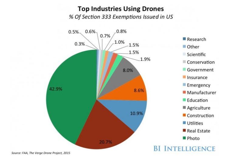
The Endurance, Range and Payload carrying capacity of modern commercial UAV’s makes them extremely useful in various applications. Businesses, organizations and law enforcements have realized the potential and benefits of using drones to help improve their offerings.
Drones are now regularly being used in the following manners:
Aerial photography for journalism, film and real estate
Real Estate, journalism, and film are using drones for aerial photography. Drones are a much cheaper option than renting a helicopter which need a pilot and film crew. They can carry HD cameras and can produce striking photos and videos.
Gathering information or supplying essentials for disaster management
Drones can survey damage, locate stranded and injured victims, and assess ongoing threats without risking the safety of rescue teams and first responders.
Infrastructure inspections
Drones are used in a variety of industries for inspection: bridges, wind turbines, solar farms/solar cells, buildings, roofs, and oil/gas pipelines. It’s difficult, costly, and risky to inspect the underside of a bridge or the top of a skyscraper. Drones do not require scaffolding, cranes, and harnesses. Just deploy the system to assess the structure’s condition remotely.
Oil & Gas
Offshore oil rigs are hard to access. With drones, engineers on shore can look for safety problems, detect oil leaks, and patrol their rigs for any sign of trespassing. Oil and natural gas pipelines cover hundreds of miles, and have to continuously be monitored. Drones are beneficial in each stage in the life of a pipeline: planning, constructing, and monitoring phases. Drones are beneficial in the route planning phase as they can give detailed terrain and topography maps of the right-of-way. Drones equipped with infrared cameras can detect heat along the pipeline, signaling a potential leak. Drones can also be equipped with a sniffer that can smell a leak.
Precision crop monitoring
Drones allow for precision crop monitoring. Using a crop management system to observe, measure, and respond to variability in individual plants, farmers can target areas requiring attention. It results in better land management and increases overall yields. Drones can also spray pesticides and herbicides on plant. They can be used to inspect plant health and detect early signs of disease.
Smuggle drugs, contraband, guns in prisons.
Prisons around the world have seen a sharp increase in use of commercial drones to drop contraband like drugs, mobile phones, blades and other weapons in prison yards. In the past year, there have been numerous instances of drones smuggling in contraband for prisoners. The Georgia department of corrections recently intercepted a payload dropped by a drone.
Drop off payloads in crowds and stadiums.
Large crowds at events, festivals or sports stadiums are especially vulnerable if a drone drops a dangerous payload. UAV’s can easily surpass traditional security barriers like metal detectors, and bag checks leaving crowds exposed to an aerial threat.
Be used for surveillance.
UAV’s can fly far distances and can cruise at high altitudes making them hard to detect or track. Therefore they can be used to survey restricted areas and gather intelligence. A drone could easily map out the security detail at an event or a prison, or observe behaviors over several days.
Hack into Datacenters.
Skilled specialists can easily modify a drone to carry a cell phone or a Raspberry Pi, transforming the drone into a “computer that can fly”. This drone can be used to hover close to corporate offices, try and detect unsecured connections, capture keystrokes, or even capture images and videos that could result in corporate espionage.
Drone with camera found on Fort Worth, Texas military base runway.
A drone found earlier this month on a taxiway at the Naval Air Station Fort Worth Joint Reserve Base has heightened concerns about the devices in secured areas. An F16 pilot reported seeing the drone on the morning of Jan. 6, 2018, and the device, which carried a camera, was found by airfield staff, according to base reports. The drone found on the runway was a Promark Drone P70-CW with a built-in WiFi signal, battery-powered, automatic takeoff and landing, and the ability to the ability to stream, record and photograph live footage to smartphones.
Drone flies within feet of plane landing at the Las Vegas McCarran International Airport.
A recent video showed a drone flying within feet of a commercial airliner as it made its approach to land at the Las Vegas airport. Airports are no-fly zones, but this reckless incident happened nonetheless potentially endangering lives of those on the commercial airliner.
Drone crashes trying to deliver contraband to Arizona State Prison.
An attempt to deliver drugs and cell phones via drone to inmates happened at Lewis Prison in Buckeye, Arizona. The attempt was unsuccessful, the drone crashed into an area only accessible to corrections officers. Prison guards were able to retrieve the drone and package. The package contained two cellphones and several freezer bags filled with marijuana.
Since, the use of UAV’s is only going to increase in the coming years, it is important for organizations to evaluate how they use drones for their benefit, but also to assess the threats a drone can pose to their respective organizations.
The first step would be to prepare a UAS risk management plan to identify potential risks drones pose to your organization. Understanding the scope of possible risks will help you develop realistic, cost-effective strategies for dealing with them. Risk identification Involves identifying sources of risk, areas of impact, and consequences.
In identifying the risk, organizations should consider these kinds of questions: “why?, what?, when?, where?, how?”
Answering some of these questions will give security professionals a better idea about their organization’s risk tolerance towards drone threats. Understanding the scope of possible risks will help you develop realistic, cost-effective strategies for dealing with drone risks.
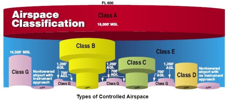
The Federal Aviation Administration (FAA) is a national authority that has the power to regulate ...
Whether you call them drones or unmanned aircraft systems (UAS), these flying contraptions are ...
Airsight is a leading sUAV security software company that specializes in delivering sUAV Airspace Detection Solutions for Critical Infrastructures, Universities, Spectator Sports, Prisons, Events, and more. Our UAV security experts integrate projects of all scopes and sizes nationwide, through a top consultative approach, to deliver the best UAV turnkey detection solution to secure your airspace. Connect with us today to discover which on our drone detection packages works best for your environment.