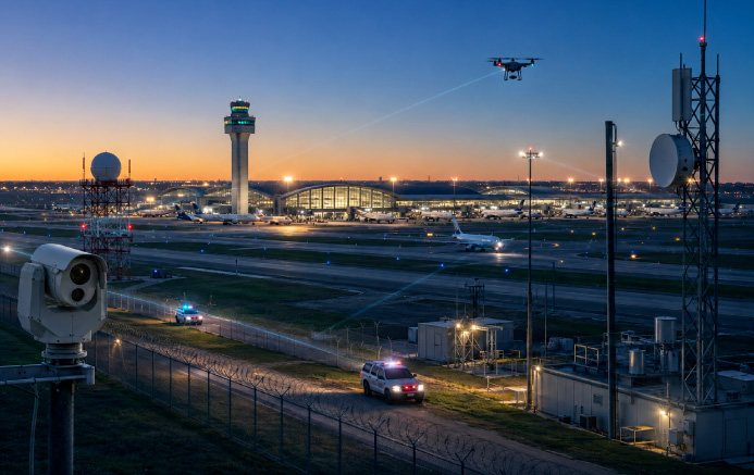
Airport Airspace Security
Airport Drone Detection
Detect and track unauthorized drones in FAA-restricted airspace in real time. AirGuard gives airport security and air traffic control a live picture of every drone near runways and terminals — plus the pilot's location — so you can respond in minutes instead of grounding the field.
The Threat to Airports
Why Airports Need Drone Detection
Airports across the United States are reporting rising numbers of drone encounters within the 5-mile FAA-restricted airspace around every airport, threatening passenger safety, flight operations, and regulatory compliance. As more drones take to the skies, airports must adopt advanced airspace monitoring to prevent a single sighting from grounding the entire field.
Runway & Flight Disruption
Drones flying near runways have repeatedly forced airports to suspend takeoffs and landings, stranding passengers and costing airlines millions per hour of downtime.
Learn MoreNear-Midair Collisions
Drones were involved in nearly two-thirds of near-miss reports at the top 30 U.S. airports in 2023 — including encounters within 300 feet of passenger jets near major hubs.
Learn MoreRegulatory & Compliance Risk
Operating a drone in controlled airport airspace without authorization is illegal. Airports must be able to detect, document, and report these incursions to satisfy FAA, DHS, and TSA expectations.
Learn MoreNo Real-Time Airspace Picture
Ground radar is built for aircraft, not small UAS. Without dedicated detection, airport teams cannot see where a drone is, where it is heading, or where the operator is standing.
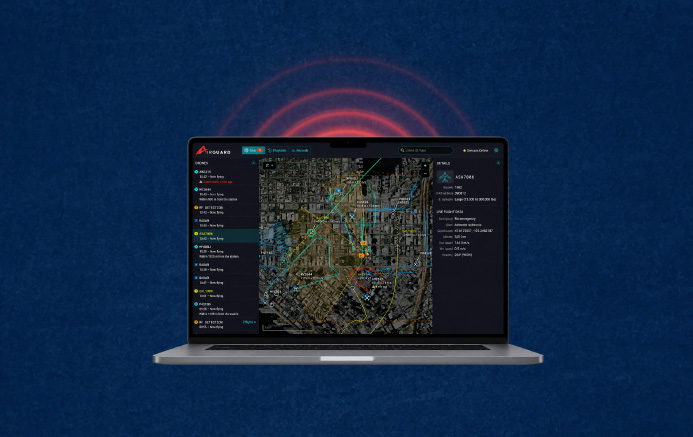
Learn MoreHow AirGuard Works
A Multi-Layered Drone Detection System for Airports
AirGuard delivers early detection, real-time drone and pilot tracking, and actionable insight to airport security teams and air traffic control — for airports of every size.
Early Threat Detection
Identifies unauthorized drones before they enter restricted airspace, reducing the risk of operational disruption.
Precise Classification
Alerts security teams to the drone's make, model, speed, altitude, and the GPS location of both the drone and its pilot.
Wide-Area Coverage
Secures entire airport perimeters, runways, and terminal airspace with layered sensor technology — including dark drones that broadcast no signal.
Live & Playback Tracking
Captures and retains drone flight history for use as digital evidence in legal and enforcement cases, verified by 24/7 human monitoring.
ADS-B Integration: Tell Drones and Aircraft Apart Instantly
In airport airspace, the hardest problem is distinguishing a genuine drone threat from the constant flow of authorized aircraft. AirGuard fuses live ADS-B data — the standard broadcast of airplane and helicopter position — directly into the AirGuard map.
That means crewed aircraft are automatically identified and set apart from unauthorized drones, helping prevent mid-air collisions, cut false alarms, and let air traffic control and security teams focus only on the threats that matter.
-
Live crewed-aircraft awareness
Airplanes and helicopters broadcasting ADS-B appear on the same map as detected drones, giving one unified airspace picture.
-
Fewer false alarms
Authorized traffic is filtered out automatically, so alerts reflect real, unauthorized drone activity — not routine flights.
-
Mid-air collision prevention
Added situational context helps teams keep drones clear of approach paths and crewed aircraft.
The Airsight Advantage
AirGuard: Best-in-Class Airport Drone Detection
A layered, open-architecture platform that gives airport security and ATC one real-time picture of their airspace — and integrates with the systems they already run.
Drone Identification & Classification
Instantly detect and classify drones, with drone-type alerts in Layer 1 notifications to help teams prioritize threats faster.
Drone & Pilot Location
Pinpoint GPS and Wi-Fi coordinates of both the drone and its operator for rapid situational awareness and enforcement.
Altitude & Position Tracking
Monitor altitude, latitude, and longitude with map-based visibility and a Zoom-to-Zone feature for your custom alert zones.
Real-Time Threat Monitoring
Track drone and pilot movements as they happen, with Copy Address functionality for instant sharing of precise incident locations.
Speed Analysis & Trends
Monitor drone velocity and analyze activity trends over 120 days for long-term airport security planning.
24/7 Live Threat Monitoring
Precise, real-time alerts on genuine drone threats, filtered by a live human monitoring team to eliminate false alarms.
ADS-B Aircraft Integration
Fuses live ADS-B airplane and helicopter data into the map to separate crewed aircraft from drones and prevent mid-air collisions.
Built for FAA, DHS & TSA Compliance
AirSight's solutions align with FAA drone detection regulations, helping airports meet federal security requirements. The platform also supports Department of Homeland Security and Transportation Security Administration guidance, with seamless integration into airport control centers and law enforcement workflows.
Because AirGuard is built on an open architecture, it unifies the systems airports already run — Video Management Systems (VMS) and PTZ cameras for visual confirmation, License Plate Recognition (LPR) to tie a pilot's location to a ground vehicle, ADS-B feeds for crewed-aircraft context, cloud analytics for trend and drop-zone mapping, and Real-Time Crime Center and Emergency Operations Center platforms for coordinated multi-agency response.
AirGuard operates passively — it detects, tracks, and documents drone activity to support a lawful response, without interfering with aircraft navigation.
Read the latest FAA drone rule update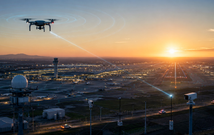
Know What's in Your Airspace
Before committing to a permanent installation, see exactly what's flying around your airport. AirSight's detection solution reveals the real pattern of drone activity over your runways, perimeter, and terminal airspace — turning a blind spot into actionable intelligence.
From there, AirSight designs a tailored, layered configuration sized to your airport, integrating best-in-class sensors without single-vendor lock-in.
Explore our detection layersThe Record
Drone Incidents at U.S. Airports
Unauthorized drones are no longer a rare event at U.S. airports — they have become a recurring operational and safety threat. The record below shows why airport airspace monitoring has moved from a nice-to-have to a federal priority.
Drone reports near U.S. airports every month
The FAA states it receives more than 100 unmanned aircraft sighting reports near airports each month from pilots, citizens, and law enforcement, and that sightings have increased dramatically in recent years.
Source: FAA — Drone Sightings Near AirportsIllegal incursions in Q1 2025 alone
The FAA recorded 411 reports of illegal drone incursions near U.S. airports from January through March 2025 — a 25.6% jump over the same period in 2024, including multiple near-midair collisions with passenger jets.
Source: The Debrief / FAA ASRS dataOf 2023 near-misses involved drones
An AP analysis of NASA's Aviation Safety Reporting System found drones were involved in nearly two-thirds of near-miss reports at the top 30 U.S. airports in 2023 — including a drone within 300 feet of a jet at San Francisco and one 50 feet from a wing near Newark.
Source: Airsight News / AP analysisThe FAA is testing detection on U.S. soil
Following a wave of Northeast sightings, the FAA launched a drone-detection testing program in Cape May, New Jersey in April 2025 to evaluate technologies that identify unauthorized drones without interfering with aircraft navigation — a clear signal that airport airspace monitoring is now a federal priority.
Source: Airsight Airport NewsQuestions, Answered
Airport Drone Detection: FAQ
Common questions from airport security teams, operations managers, and air traffic stakeholders about detecting and responding to unauthorized drones.
No. The FAA restricts drone flight in the controlled airspace around airports, and operating an unauthorized drone near an airport is illegal and can carry significant federal penalties, including fines and criminal charges. Recreational and commercial operators must obtain authorization (for example, through LAANC) to fly in controlled airspace. AirSight helps airports identify unauthorized flights that ignore these rules and pinpoint the operator's location.
A drone flying near an airport puts aircraft, passengers, and operations at risk. Even a single unauthorized drone can force a ground stop, divert flights, and create a near-midair-collision hazard — drones were involved in nearly two-thirds of near-miss reports at the top 30 U.S. airports in 2023. High-profile disruptions at airports worldwide have stranded thousands of passengers and cost airlines millions. Because ground radar is built for aircraft rather than small UAS, most airports cannot see these drones without a dedicated detection system, which is the gap AirGuard fills.
An airport drone detection system is a network of sensors and software that monitors the airspace around an airport for unauthorized drones, classifies them, and alerts security teams and air traffic control in real time. AirGuard layers multiple sensor types — Remote ID, RF and Directional RF detection, radar, acoustic sensors, and PTZ camera verification — to catch both signal-emitting and "dark" drones across runways, terminals, and the perimeter. Because it is built on an open architecture, airports aren't locked into one vendor: it integrates best-in-class hardware from partners such as Echodyne, Fortem, Axis, and FLIR, delivering each drone's make, model, speed, altitude, and GPS location plus the pilot's live position from a single interface.
Yes. AirGuard fuses live ADS-B data, which broadcasts the position of crewed airplanes and helicopters, directly into its map, so the platform can separate authorized aircraft from unauthorized drones and help prevent mid-air collisions. On the radar side, AI-powered classification further differentiates drones from birds, aircraft, and environmental clutter. In a busy airport environment this reduces false alarms and lets security teams and ATC focus on genuine drone threats.
AirGuard issues real-time alerts via pop-up, email, and SMS the moment a drone enters a defined alert zone. Security teams immediately see the drone's flight path and the pilot's live GPS location, while PTZ cameras provide on-demand visual confirmation. The platform can also push live threat data into Real-Time Crime Center and Emergency Operations Center dashboards, enabling a coordinated response with airport operations and law enforcement — without unnecessarily halting flights across the entire field.
AirSight's detection-only solutions align with FAA regulations and support DHS and TSA guidance. Detection — monitoring and identifying drones in your airspace — is legal for any facility. Mitigation, such as jamming or disabling a drone, is federally restricted to specific authorized agencies, which is why AirGuard focuses on detection, tracking, and actionable intelligence to support a lawful response.
Airsight acts as a vendor-neutral validator rather than a single-hardware reseller. The company purchases and stress-tests detection equipment from global vendors at its Dallas headquarters and dedicated test sites, integrating only the technology that proves reliable into the AirGuard platform. This open-architecture approach eliminates single-vendor lock-in, lets each airport deploy best-in-class sensors suited to its environment, and is backed by a 24/7 expert monitoring team that verifies alerts so teams respond only to confirmed threats.
Secure Your Airport's Airspace
See what's flying around your runways and terminals. Book a demo or take our airspace detection solution for a spin before committing to a permanent system.